According to the UNDP, the global population is projected to reach almost 10 billion people by 2050, necessitating a 98% increase in food production. Extreme and unpredictable weather events driven by climate change, which threaten agricultural productivity, are complicating this challenge.
What is Precision Agriculture?
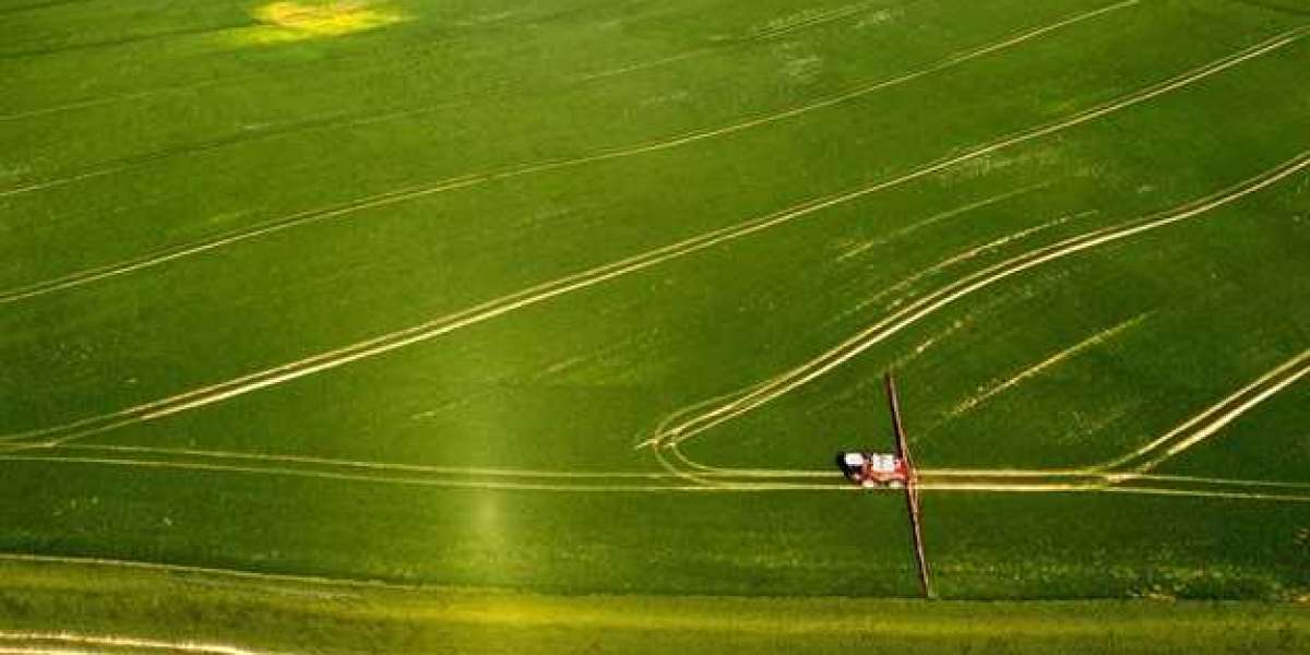
Precision agriculture (also known as precision farming or smart farming), applies information technology, data analysis, and various tools to optimise agricultural production. The goal is to maximise yields, minimise waste and inputs (e.g., water, fertilisers, and pesticides), and improve overall efficiency in farming operations. Precision agriculture encompasses satellite-guided tractors, autonomous robots, drones, soil-analysing field sensors, and even specialised smartphone apps.
The U.S. Government Accountability Office (GAO) highlights that precision agriculture technologies benefit farmers, society, and the environment by optimising resource use and improving productivity. A 2021 study found that farmers using these technologies saw a 4% increase in crop production, a 7% improvement in fertiliser efficiency, a 9% reduction in pesticide use, a 6% reduction in fossil fuel use, and a 4% reduction in water use.
Use of Satellite Imagery for Precision Agriculture
Since the launch of the first Landsat satellite in 1972, satellite imagery has been a staple in agriculture. Traditional multispectral imaging (MSI) has provided valuable insights but is limited in spectral resolution, hindering the ability to detect subtle changes in crop health and biochemical parameters.
Recently, hyperspectral imagery has become a powerful tool for detailed insights into crop health. Hyperspectral sensors can collect data across multiple bands, enabling accurate pest detection, analysis of invasive species and diseases, monitoring of soil health and nutrient content, and assessment of chlorophyll content in vegetation.
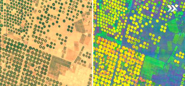
The high spectral resolution of Pixxel hyperspectral imaging satellites (right) allows for the extraction of precise spectral signatures of croplands, thus allowing for the distinction between different varieties of the same crop (Tubarjal, Saudi Arabia).
How Hyperspectral Imaging Excels Over Multispectral Imaging
Hyperspectral imaging surpasses conventional methods such as RGB or multispectral imaging. Unlike MSI, which captures data in discrete bands, hyperspectral sensors record a continuous spectrum across the visible and near-infrared ranges. Each pixel in a hyperspectral image corresponds to a unique spectral signature, offering a detailed and comprehensive view of crop health.
Until recently, satellite-based hyperspectral imagery was primarily driven by government-led space missions. However, advancements in sensor technology have led to commercial ventures like Pixxel pioneering new avenues in spaceborne hyperspectral imaging.
Benefits of Hyperspectral Technology in Precision Agriculture
Hyperspectral imagery enhances precision agriculture by capturing detailed information across multiple bands, often numbering in the hundreds. This technology allows agricultural organisations to differentiate between vegetation types or species and estimate crucial biophysical and biochemical properties such as leaf area index, biomass, chlorophyll, and leaf nitrogen content. With this comprehensive data, organisations can detect subtle differences in crop health, soil composition, and nutrient levels, allowing for earlier and more precise identification of issues such as disease, pest infestations, and nutrient deficiencies.
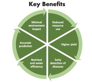
Enhanced Precision: Hyperspectral imaging provides high-resolution imagery to pinpoint variations within a single field. These granular details allow farmers to identify specific areas needing attention, enabling targeted interventions. High-resolution imagery ensures close monitoring of every part of the field, leading to more efficient and effective farming practices.
Efficient Data Collection: Hyperspectral sensors gather comprehensive data on various variables, from soil moisture levels to crop stress indicators, streamlining data collection and analysis. This efficiency reduces the time and resources needed for decision-making, enabling quicker responses and up-to-date field monitoring without extensive manual sampling.
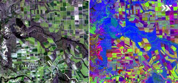
The hyperspectral image (right) highlights the superior level of detail, enabling the analysis of parameters such as leaf chlorophyll content, biomass, and growth stages (Burdekin Shire, Australia). Source: Pixxel
Terrain Accessibility: Satellite-based hyperspectral sensors are not limited by challenging terrain. Whether it's rolling hills, valleys, or flat plains, hyperspectral sensors can collect consistent and reliable data across diverse landscapes. This versatility ensures that all farmlands can benefit from precision agriculture, regardless of their geographic characteristics.
Real-Time Monitoring: One of the standout features of satellite-based hyperspectral imagery is its ability to provide real-time monitoring. Farmers can receive instantaneous updates on crop health and field conditions, allowing for timely interventions. This real-time capability addresses issues before they escalate, ensuring optimal crop growth and productivity.
The Way Forward
Hyperspectral imaging has revolutionised precision agriculture, ushering in more sustainable and productive farming methods. Despite challenges such as high costs and limited data availability, the long-term benefits of this technology outweigh the initial investment. By providing precise and accurate data, hyperspectral imagery reduces the need for broad-spectrum pesticides and fertilisers, cutting costs and minimising environmental impact. Moreover, early issue detection helps prevent crop losses, ensuring consistent yields and income for farmers.
While the availability of satellite-based hyperspectral imagery remains a concern, advancements in technology and increased commercial space activity are expected to address this challenge. Companies like Pixxel are leading the change with their cutting-edge hyperspectral imaging satellites, offering high-resolution imagery, precise spatial accuracy, and frequent revisits. These innovations empower stakeholders in agriculture with vital data for optimised practices and sustainable food production.
Contact their sales team for an in-depth understanding of how Pixxel's technology can benefit your organisation.
FAQs
1.What is precision agriculture?
Precision agriculture is an approach that uses technology and data analysis to optimise production, minimise waste, and improve efficiency.
2.How does hyperspectral imaging benefit precision agriculture?
Hyperspectral imaging provides detailed insights into crop health, soil composition, and nutrient levels, enabling early detection of disease and pest infestations.
3.Why is satellite imagery important in agriculture?
Satellite imagery allows farmers to monitor large land areas, identify patterns, and make informed irrigation, fertilisation, and pest control decisions.
4.What are the advantages of real-time monitoring in agriculture?
Real-time monitoring enables farmers to respond quickly to changes in crop conditions, preventing losses and maximising yields.
5.How can precision agriculture technologies help address environmental concerns?
Precision agriculture reduces the use of resources like water, fertiliser, and pesticides, minimising environmental impact and promoting sustainable farming practices.


